Showing posts with label trail. Show all posts

Friday, April 27, 2018

David English and Twin Ponds Cut-Off Trail


Location: White Clay Creek State Park, Newark, Delaware
Season Visited: Spring
Trail Length: David English Trail is 2.4 miles long. If you make it a shorter loop from the park office by taking the Twin Ponds Cut-Off Trail, I estimate the hike to be about 1.6 miles. The cut-off trail itself is 0.4 miles. You can see the layout of the trail (and other trails in the park) on this map.
Time to Hike: Hiking the full David English Trail took us about 2 hours, going at a toddler's pace some of the way. Doing the short loop via the cut-off trail when said toddler was a small baby took us 1.5 hours.
Difficulty Level: Moderately easy.

I have written before about trails in White Clay Creek State Park. This post is actually two posts in one, as I have hiked this trail twice now. The first time was in May 2017 when my son was three months old. The first part of this post and the accompanying pictures are from that hike. The goal that day was to hike the entire David English Trail, but the baby was not having it and we ended up taking the cut-off trail to make a shorter loop back to our car. The second time was a couple of weeks ago, the beginning of April, with a much more adventurous 14-month-old! This park is close and pretty and has easy hikes - perfect for a new mom or families with young children. The David English Trail in particular is a good choice because you can decide at the halfway point whether you want the hike to be short or a bit longer depending on how your family is feeling. Be warned: on a warm April day you will have to get out of the way of a LOT of bikers.

Both times, in addition to my son, I went with my husband and sister to the hike, which starts at a trailhead at the following coordinates, near a park office:


One nice thing about the White Clay Creek trail markers is that they include coordinates!

As you can see on the map, the trail has three different ways you can go almost immediately. We decided to go left here. This put us directly on the David English Trail, walking on relatively level ground. Going right would also have put us on the David English Trail, but there looked to be an incline, and we decided to go easy on ourselves since this was only my second-ever hike with the baby back in 2017. What followed was a mostly flat dirt trail.


With the newest addition!

My sister is obviously highly enjoying her quality time with nature.


Further on we came to a bench, where I fed the baby and let him chill out of the carrier for a while. At the time I was experiencing quite a bit of difficulty hiking with him because he did not like the carrier under most circumstances. Now that he can sit in a backpack - or walk - he has taken to hiking with joy.

It was only a year ago, but he looks so much smaller than he does now, as you will see!


Here you can see how the trail looks in April from our most recent trip:

There is much less foliage in April. This is the trail just past the parking lot.

Past the bench the trail opens up, coming to a sweet little pond filled with turtles, and where we spotted many small birds. Both times I've been to this pond I've seen eastern bluebirds. After the pond, the trail meanders back into the woods. Near the end it becomes a bit more steep, and you do have to put in a bit of effort, especially if carrying a toddler on your back. It's never difficult, however. In season you can see a lovely magnolia tree blooming near the park office before returning to the parking lot. These pictures are from the April 2018 trip.

My sister and dog.

Baby boy loves hanging out in the Osprey carrier.


Conked out.

I was very happy to be able to complete the trail this time around. A successful hike with my son has definitely renewed my confidence as I begin to hike more often with him. I can't wait to share more of our adventures with you.

Tuesday, August 25, 2015

Laurel Prong and Hazeltop

Location: Shenandoah National Park, VA
Season Visited: Spring
Trail Length: 7.4 miles (about 4.3 miles on Day One and 3.1 miles on Day Two)
Time to Hike: 2 days
Difficulty Level: 2

I completed my first backpacking trip of 2015 back in the first week of April, and then had such a good time that I went back again two weeks later with my husband and my dog!  This hike is a great backpacking trip for beginners in moderate shape.  It's enough to give you a workout but not enough to exhaust you.  If I was ever taking a complete beginner on a trip, this would definitely be one of my go-to trails.

I used this itinerary and this map for my trip.

The hike starts at Milam Gap parking, between mile 52 and 53 of Skyline Drive.  It's a good-sized parking lot and finding a spot was not an issue at all.  Cross Skyline Drive pretty much immediately to head south on the Appalachian Trail.

AT post after crossing Skyline Drive.

Hike the AT for 2.6 miles and then turn left on Laurel Prong Trail, where you will be sleeping for the night.  Everything is well-labeled and easy to follow.  I always check the posts, even if I know where I'm going, to ensure I'm never lost.  There are some beautiful views of the mountains, if you look for them.  The first time I hiked this trail I totally missed an amazing viewpoint that my smart little dog scoped out the second time.

Cleo the hiking yorkie-poo is at it again!


Laurel Prong Trail turns sharply left at one point (you can see it on the map), taking you along a really neat ridge with rock formations.  Hiking for a while after the ridge you return to the woods, and if you're looking for it, there is a very obvious camping spot on the right-hand side of the trail.  It's just before a tiny creek crossing, so if you've come to that then you've gone too far.  This little creek beyond camp is where we filtered our water.

Ridge line - the first time.


Cleo on the ridge.

The campsite is spacious, but we did have to clear a bunch of fallen branches out of the way that were not there two weeks before.

Cleo by the creek.


The next day is exceptionally interesting.  As Sean said, the first day can be a bit boring if just walking in the woods isn't enough for you.  The second day features some awesome history at Rapidan Camp!

If you camped in the big spot on Laurel Prong trail you've got a little while before you see Fork Mountain trail go off to your right (which you bypass).  In the spring, the trail can definitely be wet, but if you're hiking this time of year you're probably already prepared for that, right?

Wet, early morning trail.

The intersection with Fork Mountain.  You can't camp past this point.

Follow Laurel Prong along and you will come to the really cool Rapidan Camp.  Explore the area!  There are neat historical buildings, both a wooden and metal bridge, and a waterfall.  During normal hours I think they have rangers and exhibits there, but I was either way too early in the morning or too late in the evening when I went.  Personally, I very much enjoyed the solitude.


There's also this little trail called Five Tents Trail that spurs off of Laurel Prong.  It's really short but steep if you're already a little winded, and to be honest there's really nothing there but an old foundation.  I guess if you're into foundations then, by all means, go check it out, but there's nothing you didn't already see at the Camp itself.

When you've had enough, find Mill Prong trail.  It was a little hard for me to find at first but once I saw the post it was pretty obvious.  Just look for the metal bridge.  It's right around there.  FYI - there is an outhouse past the metal bridge (which I did not take a picture of, sorry).  That outhouse was NOT stocked with toilet paper at the time I went, even though it had a dispenser.  And that was really unfortunate, because the second time I went I ran out of toilet paper.  And had to use a leaf.  So yeah, just so you know.

Post at the beginning of Mill Prong.

Waterfall on Mill Prong Trail.

Stones to cross, in front of the waterfall.

So, you may or may not know this, but one of Shenandoah's most magical features is the large-flowered trillium that blooms in the park between March and May.  It is the park's logo and is a spectacular flower.  The first time I made this trip in the first week of April, the trillium had not yet bloomed.  But in the middle of the month it was all around this waterfall.  Seeing trillium in Shenandoah is one of my favorite things and the blooms around the waterfall were just gorgeous.

Large-flowered trillium.


Past the waterfall a bit you will see the split for Mill Prong and the Mill Prong horse trail.  Be sure to stay left on Mill Prong, because the horse trail ends up very out of your way!  After that you will encounter two stream crossings, neither of which is daunting.  Finally, the brush will change and you will make your way up a small rise back to Skyline Drive and the parking area.

Mill Prong and Mill Prong horse trail split.

First stream crossing.

Second stream crossing.

Slight incline at the end of the trail.

And that's the hike!  Remember on your drive home to keep an eye out for deer on Skyline Drive.  They're EVERYWHERE.  And keep on wandering :)


Sunday, April 28, 2013

Avebury Walking Trail

Location: Avebury, Wiltshire, England
Season Visited: Fall
Trail Length: There are many trails to take throughout Avebury.  The one I'm describing runs from the village to West Kennet Long Barrow, and is about 4 miles there and back.
Time to Hike: 2.5 hours
Difficulty Level: 2

I'm excited about this post because it's so different from the others I've posted in pretty much every way.  This is one of two real "trails" I've ever walked in another country, and that alone makes it something special.  I lived in England for a little over two months, and I saw countless extraordinary places while abroad, but Avebury was perhaps the most unique of them all.

Let me start by saying that Avebury is absolutely amazing.  If you have any interest whatsoever in the mysteries of ancient standing stones (and who doesn't?) then you need to come to Avebury.  I went to both Avebury and Stonehenge while I was abroad and found Avebury more fascinating and enjoyable in every way.

I lived in Oxford, and while I was there I took a different trip around the country every weekend.  Avebury was my first, which is undoubtedly part of the reason why I have such great memories of it.  My trip to Avebury was the first time I had ever really planned a trip for myself and was also the first time I took public transportation by myself.  I went to Avebury alone just to make sure I could, and it was a fantastic decision.

I began my tour of Avebury at the village and main henge.  Here is a lovely map of the area (the whole website is actually really awesome).  It was a perfectly English October day (cloudy with a chance of showers, then sun, then maybe some more showers...) and I had all of Avebury pretty much to myself.  It was heavenly.  I began just by walking around the village and main henge.  It was magical.


Sheep are everywhere... watch your step.


The little obelisks mark where stones used to be.  You can read about the destruction of some of the stones here.


When you go to Avebury, be sure to check out the church and the manor after enjoying this first set of stones.


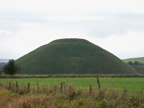
After this main area is where the real fun begins.  Follow the trail south towards the amazing Silbury Hill.  The walk is beautiful.

Pass the stones.  Enter the trail.


Silbury Hill is beyond fascinating.  Read all about it.

Don't stop now!  After admiring Silbury Hill you have one more amazing stop to make... West Kennet Long Barrow.


It was kind of spooky in there.

The barrow is so cool, and is well worth the long walk to get there.  All you have to do now is enjoy the way back.


Obviously, Avebury is a truly breathtaking place.  I wish there were places like this in the U.S., places that connect you to people so much older than yourself.  They are few and far between, I think.  If you are ever lucky enough to have the opportunity, go to Avebury.  You won't regret it.  Enjoy your hike, and keep wandering.