Sunday, April 28, 2013

Avebury Walking Trail

Location: Avebury, Wiltshire, England
Season Visited: Fall
Trail Length: There are many trails to take throughout Avebury.  The one I'm describing runs from the village to West Kennet Long Barrow, and is about 4 miles there and back.
Time to Hike: 2.5 hours
Difficulty Level: 2

I'm excited about this post because it's so different from the others I've posted in pretty much every way.  This is one of two real "trails" I've ever walked in another country, and that alone makes it something special.  I lived in England for a little over two months, and I saw countless extraordinary places while abroad, but Avebury was perhaps the most unique of them all.

Let me start by saying that Avebury is absolutely amazing.  If you have any interest whatsoever in the mysteries of ancient standing stones (and who doesn't?) then you need to come to Avebury.  I went to both Avebury and Stonehenge while I was abroad and found Avebury more fascinating and enjoyable in every way.

I lived in Oxford, and while I was there I took a different trip around the country every weekend.  Avebury was my first, which is undoubtedly part of the reason why I have such great memories of it.  My trip to Avebury was the first time I had ever really planned a trip for myself and was also the first time I took public transportation by myself.  I went to Avebury alone just to make sure I could, and it was a fantastic decision.

I began my tour of Avebury at the village and main henge.  Here is a lovely map of the area (the whole website is actually really awesome).  It was a perfectly English October day (cloudy with a chance of showers, then sun, then maybe some more showers...) and I had all of Avebury pretty much to myself.  It was heavenly.  I began just by walking around the village and main henge.  It was magical.


Sheep are everywhere... watch your step.


The little obelisks mark where stones used to be.  You can read about the destruction of some of the stones here.


When you go to Avebury, be sure to check out the church and the manor after enjoying this first set of stones.


After this main area is where the real fun begins.  Follow the trail south towards the amazing Silbury Hill.  The walk is beautiful.

Pass the stones.  Enter the trail.


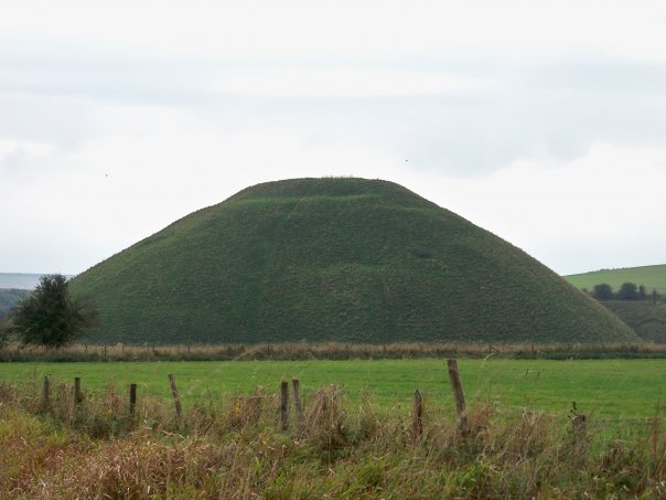
Silbury Hill is beyond fascinating.  Read all about it.

Don't stop now!  After admiring Silbury Hill you have one more amazing stop to make... West Kennet Long Barrow.


It was kind of spooky in there.

The barrow is so cool, and is well worth the long walk to get there.  All you have to do now is enjoy the way back.


Obviously, Avebury is a truly breathtaking place.  I wish there were places like this in the U.S., places that connect you to people so much older than yourself.  They are few and far between, I think.  If you are ever lucky enough to have the opportunity, go to Avebury.  You won't regret it.  Enjoy your hike, and keep wandering.


Sunday, April 21, 2013

Gorham Mountain Trail

Location: Acadia National Park, Bar Harbor, Maine
Season Visited: Summer
Trail Length: 1.8 miles
Time to Hike: 2 hours
Difficulty Level: 3

Gorham Mountain Trail is a beautiful and fun hike in a spectacular national park.  I'm obsessed with national parks, but since I live on the east coast I've only been to two of them.  I love Shenandoah and make my yearly pilgrimage, but there's something more magical about Acadia.

Maybe it's because the landscape is so rugged, maybe it's because I have a love affair with Maine, or maybe it's because my husband proposed to me here, but Acadia National Park has a special place in my heart.  A trip to Acadia doesn't happen every year, so it's always a momentous occasion.  Time spent in Acadia is time spent with adventure.

As this brochure tells you, there are trails for all skill levels in Acadia.  Next time I go I really want to knock out some of the hard ones (I've heard great things about Beehive, Cadillac, and Dorr, so look out for those posts in the future!), but this past trip I focused on a moderate one for starters.  Now, I am generally convinced that Maine has an entirely different scale of rating trails than any other state on the east coast, but I think it's safe to say that this trail is indeed "moderate," as the chart on the brochure suggests.

The trail begins amongst the woods and rocks of Acadia.  There are some fun stone formations and even something that looks like a cave.  There are beautiful viewpoints along the way.

Green pines and blue skies on a gorgeous August day.

There is a false summit, so don't be fooled.  Enjoy the views and keep right on going until you reach the very top.  For such a small mountain, the amount of scenery you can see is truly astounding.

Mist rolling onto shore.


Typical Acadian beauty.

Hopefully you've taken full advantage of the photo ops.  Enjoy both flora and fauna on the way back down!

Birch and fern bottom.  Very different from the pine and rock top!


There are so many things to do in and around Acadia that you can't possibly be bored.  If you're feeling adventurous, try another hike!  If not, just drive around and enjoy the scenery.

Thunder Hole.

Tide pool.

View from Cadillac Mountain.

Bass Harbor Head Light.

Seals.

Enjoy your hike, and keep wandering!

Sunday, April 14, 2013

Moose Trail

Location: Spencer Bay, Moosehead Lake, ME
Season Visited: Summer
Trail Length: approximately 1 mile there and back
Time to Hike: about an hour
Difficulty Level: 2

Moose Trail, the trail head of which is located in Casey's Spencer Bay Camps, is a hidden gem.  It is so precious to me that I almost considered not sharing it, because it is little-known (although that is changing) and is one of my favorite places in the world.  I have a very special connection with the area, mostly based in many summers spent there as an adolescent.  Some of my favorite moments in the state of Maine have been spent on this trail, and they are moments that I will never forget.

Since this trail has such nostalgic value for me, you'll have to forgive a few reminisces and more flowery language than I usually use.  To me, this trail represents everything beautiful.  The smell of pine, the colorful stones at Pebble Beach, the wildlife - all of these things make Moose Trail special.  I have walked the path many times.  One time I witnessed a fantastic sunset here (Spencer Bay has some of the most beautiful sunsets I've ever seen).  Another time some friends and I wandered down a side trail and got chased by an entire swarm of bees!  Okay - maybe that memory is only fond for me because I didn't get stung.  Ask my poor sister about it and you might hear a different story (she was stung ten times).  At least it was an adventure!

Don't let the bee story discourage you, though.  The trail is relatively bug-free as long as you don't go in June, during the black fly season.  Well, except for the dragonflies in the pond... and the spiders on the beach... and sometimes the horseflies around the water... but this is nature, folks!

So, Moose Trail begins at Casey's Camps.  There's pretty much nothing around there (the town of Greenville is like 45 minutes away), so you're really only there if you are camping there or staying somewhere else nearby on Moosehead Lake.  You begin on the Moosehead Lake side of the peninsula, up past camp site 8.  You'll see the beginning of the trail on this map of the camp ground, up in the left-hand corner.

Moose Trail follows the coast of the lake.  The trail is made of dirt and root, and the abundant pine trees and moss are truly spectacular.  You get a wonderful sense of solitude and peace if you walk this trail alone.  I love knowing that there is nothing around for miles and miles but nature.


A dense cluster of pine.  It becomes dark in this section no matter how bright the sun is shining, and you can't help but wonder what is lurking just beyond your line of sight.

Re-emerging into the light.

After walking through these pine woods, you will suddenly come to a strip of pebbled beach in between the lake and a small, lovely pond teeming with ducks and dragonflies.  There seems to always be little ducklings swimming around here, and they are pretty much the most adorable things on the planet.  I always stop here to admire the beauty of the lake and mountains on one side of me and the pond and forest on the other.

Pebbles beneath my feet.

Mama duck watching the babies.

The pond is very still and the reflections are beautiful.


One of the many blue dragonflies that live by the pond.

The lake view.


Keep going and you will re-enter the forest.  Right at the edge close to the pond lives a very friendly group of black-capped chickadees, the state bird of Maine.  You may know that black-capped chickadees are extremely sociable and can be easily trained to eat out of your hand.  Bring some birdseed along and see what happens!


Walk just a little further and you'll be out of the woods and at the end of the trail.  Here is your destination: Pebble Beach, a long stretch of, you guessed it, pebbled beach!  Bring a swimsuit and towel and take a dip. There are usually a few other people swimming here, and the view is gorgeous.  Don't worry about the little spiders, they're just trying to sun themselves.  Just remember to bring water shoes - the pebbles can hurt your feet and the waters house some crayfish!

Playing in the water.

Flowers on the rocks.


When you're finished playing, re-trace your steps and head back.

I hope you enjoy your hike on Moose Trail.  If you're back at Casey's before dark, don't forget to go "moose hunting" in your car on the road out of the camp!  Keep wandering, and enjoy your hike!

Moose on the loose!

Here is a video of a sunset at Moosehead Lake that I took a few years ago.


Tuesday, April 2, 2013

Boone, Horseshoe, and Ridge Trails

Location: French Creek State Park, Elverson, PA
Season Visited: Spring
Trail Length: 3-mile loop
Time to Hike: Two and a half hours
Difficulty Level: 3

French Creek State Park is a spacious park popular with those living in the Philadelphia area.  From my home in Pennsville, NJ it's about an hour and 45 minutes away, so it's only a little more than an hour from Philly.  The park features 35 miles of trails used for hiking, mountain biking, and horseback riding.  The trails are well-kept, but, as you will see, are not well-marked on the map.  You have been warned.

Having about four hours to hike, I decided to go with Turtle Trail based on its description on the park's website.  The mileage and difficulty level sounded like what I wanted to get into, so I stopped at the park office on arrival (we came in on South Entrance Road from Route 345) and asked how to access Turtle Trail.  The lady at the desk told me to park at Hopewell Lake, and then take Boone Trail to connect with Horseshoe Trail, which would lead me to Turtle Trail.  I left and related this information to my sister and her boyfriend, my hiking companions for the day (along with my dog).

We began at Boone Trail, which we accessed from Park Road by Hopewell Lake.  We came to the fork in the trail indicated by the map, and here's where things first started to become confusing.  The trail to the left was called Horseshoe Trail, while on the map it was called Turtle Trail.  Not once on the trail itself did signs refer to the trail as Turtle Trail, but it appears that they are one-in-the-same for at least part of the trail.  We spent some time on this trail before deciding that we wanted to see the Hopewell Fire Tower, so we began looking out for Ridge Trail.  Here are some images of our time on Turtle/Horseshoe Trail.


After some confusion due to unlabelled turn-offs and such, we made it to the intersection of Ridge and Horseshoe Trail.  When you come to this on your own hike, be aware that it is unclear what color blazes Ridge Trail is supposed to have.  It turns out that the trail is a red-blazed trail instead of the yellow and white blazes that you have been following up to this point.

Upon following Ridge Trail we came to Fire Tower Road.  Now on the map, it seems that you make a left on Fire Tower Road to continue following the trail and come to the fire tower.  We went this way and followed it for some time with absolutely no sign of the trail or the fire tower.  We decided to turn around and follow the road to the parking area on the map, and in this way we found the Hopewell Fire Tower.  My advice?  Just turn right on the road to begin with.

The Hopewell Fire Tower.  Be aware that it is surrounded by a barb-wire fence, so you cannot climb it (much to our disappointment).

Buildings and a picnic area around the fire tower.


After a snack at the fire tower, we went to the end of the road (make a left when you come to the road after turning away from the fire tower) and connected back with Boone Trail.  This brought us back to where we started, but not before bringing us to the Majestic Underpass and some other fun fallen trees.


All in all, our spur-of-the-moment combination of Boone, Horseshoe, and Ridge (and Turtle?) trails was a fun adventure.  I can't say that this was one of my favorite hiking trips, but it was worth it.  We only saw one other person our entire time on the trail, so visiting in early April seems to be great for solitude.  If you live around French Creek, take advantage of it!  Just be ready for some confusion with the map :)

Here is a video of our day's adventures.  Enjoy your hike, and keep wandering.